Trail Other activity La Chapelle-d'Abondance - chapelle d abondance Trebentaz chapelle d abondance - Photo

chapelle d abondance Trebentaz chapelle d abondance

© OpenStreetMap contributors
Length
Length
13.9 km
Max alt
Max alt
2012 m
Uphill gradient
Uphill gradient
1077 m
Km-Effort
Km-Effort  
28 km
Min alt
Min alt
996 m
Downhill gradient
Downhill gradient
1077 m
Boucle
Boucle
Yes
Creation date :
2015-08-20 00:00:00.0
Updated on :
2015-08-20 00:00:00.0

(0 Reviews)

Other activity
Other activity
4h51
Difficulty : Difficult

Scan this QR Code to open this trail in the SityTrail application

FREE GPS app for hiking

Logo SityTrail SityTrail

IGN / Geographical institutes

Download SityTrail from the App Store Download SityTrail from Google Play

Logo SityTrail SityTrail World

The world is yours!

Download SityTrail from the App Store Download SityTrail from Google Play Download SityTrail on Huawei AppGallery

About

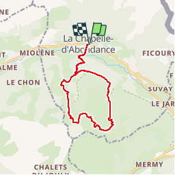
Trail Other activity of 13.9 km to be discovered at Auvergne-Rhône-Alpes, Upper Savoy, La Chapelle-d'Abondance. This trail is proposed by patricee2p.

Description

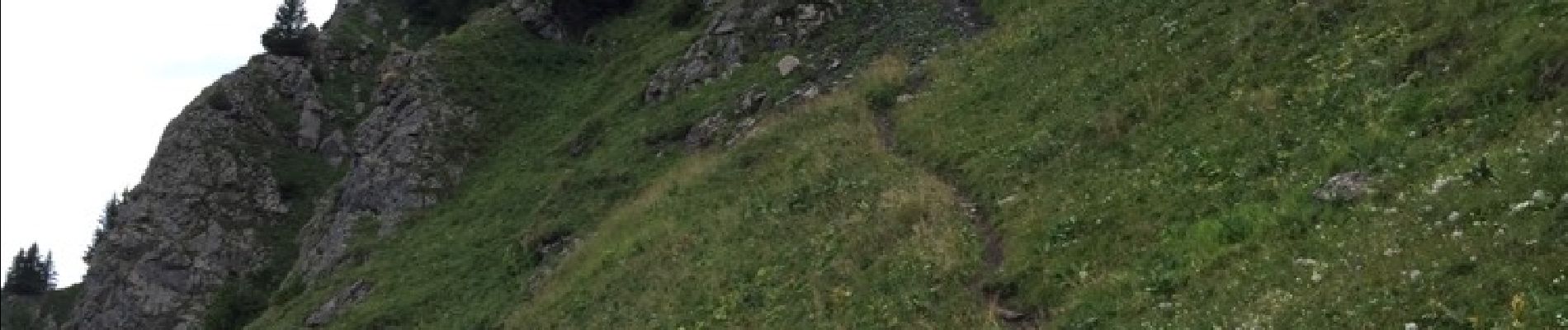
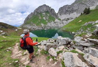
Montée au refuge de Trebentaz avec déjeuner super vue magnifique et descente sur l'autre versant

Elevation profile

Photos

Positioning

Country:
France
Region :
Auvergne-Rhône-Alpes
Department/Province :
Upper Savoy
Municipality :
La Chapelle-d'Abondance
Location:
Unknown
Start:(UTM)
329731 ; 5129224 (32T) N.

Trails nearby

Trail Walking La Chapelle-d'Abondance - Le Linleu 2093 m, depuis Sevan-devant - Photo
Walking
tracegps

Walking

Medium
(1)
La Chapelle-d'Abondance, Auvergne-Rhône-Alpes, Upper Savoy, France
5.1 km | 11.9 km-effort
3h 0min
Yes
Trail Walking Abondance - Le Mont de Grange, 2432m - Photo
Walking
tracegps

Walking

Difficult
(1)
Abondance, Auvergne-Rhône-Alpes, Upper Savoy, France
10.9 km | 25 km-effort
7h 0min
Yes
Trail Walking La Chapelle-d'Abondance - Les Cornettes de Bise par le sentier de Saix Rouquin - Photo
Walking
tracegps

Walking

Difficult
(1)
La Chapelle-d'Abondance, Auvergne-Rhône-Alpes, Upper Savoy, France
10 km | 25 km-effort
6h 30min
Yes
Trail Walking La Chapelle-d'Abondance - Cascade boucle 2 - Photo
Walking
Derrendinger

Walking

Difficult
(1)
La Chapelle-d'Abondance, Auvergne-Rhône-Alpes, Upper Savoy, France
10.1 km | 14.9 km-effort
3h 23min
Yes
Trail Snowshoes Châtel - Petite  Châtel - Photo
Snowshoes
GUIDE
pascalou73

Snowshoes

Medium
Châtel, Auvergne-Rhône-Alpes, Upper Savoy, France
5.7 km | 10.6 km-effort
2h 0min
Yes
Trail Snowshoes Châtel - Randonnée entre la France et la suisse  - Photo
Snowshoes
GUIDE
pascalou73

Snowshoes

Easy
Châtel, Auvergne-Rhône-Alpes, Upper Savoy, France
5.8 km | 8.5 km-effort
2h 3min
Yes
Trail Walking La Chapelle-d'Abondance - lac darbon - Photo
Walking
tof38

Walking

Easy
(1)
La Chapelle-d'Abondance, Auvergne-Rhône-Alpes, Upper Savoy, France
5.9 km | 13.7 km-effort
3h 54min
No
Trail Walking Vacheresse - Tour du Mont Chauffé  - Photo
Walking
reneperrin

Walking

Medium
Vacheresse, Auvergne-Rhône-Alpes, Upper Savoy, France
12.7 km | 23 km-effort
5h 12min
Yes
Trail Walking La Chapelle-d'Abondance - CORNETTES DE BISE: LAC DE DARBON - Photo
Walking
djeepee74

Walking

Medium
La Chapelle-d'Abondance, Auvergne-Rhône-Alpes, Upper Savoy, France
7.7 km | 16 km-effort
3h 30min
Yes


Close
My subscriptions